• Link to Instagram
  • Link to Youtube
  • Home
  • Image Licensing
  • About
  • Articles
  • Blog
  • Contact
  • Email List
68 North
  • Ebooks
  • Photo Tours
  • Portfolio
  • Video
  • Lofoten Hikes
  • Outdoors
    • Lofoten’s 3 Best Beaches
    • Lofoten Beach Guide
    • Hiking – Introduction
    • Camping – Overview
    • Mountain Huts
    • Lofotoden National Park
    • Winter Hiking
  • Travel Info
    • When To Go
    • Getting To Lofoten
    • Getting Around The Islands
    • Winter Driving
    • What To Wear
    • Lofoten On A Budget
    • Seasons on Lofoten
    • Sunrise – Sunset
    • Northern Lights
    • Midnight Sun
    • Drone Photography On Lofoten
  • Click to open the search input field Click to open the search input field Search
  • Menu Menu

Skottinden, Lofoten Islands, Norway

Mountain Name: Skottinden – Location: Vestvågøya – Elevation: 671m – Difficulty: Hard/Steep – Time: 1.5-2 hours

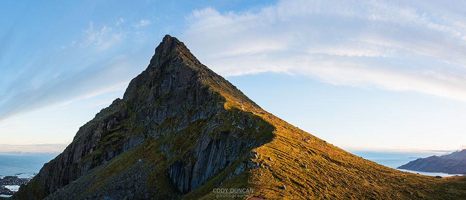
If there is to be a ‘Matterhorn of Lofoten,’ then this designation surely belongs to Skottinden.  Rising from the southwestern peninsula of Vestvågøya, Skottinden is an imposing mountain peak rising high above the waters of the Nappstraumen.  From nearly any point on Vestvågøya, the mountain is an eye-catching sight that begs for a journey to the summit by any adventurous hikers.  While most of the route is little more than steep hiking, to reach the final summit requires some airy scrambles over steep rocks situated above the sheer cliffs of the east face.  This final section may not be for the faint of heart or the inexperienced.

Getting There

Getting to the trailhead requires a bit more street navigation than usual for the Lofoten Islands.  From any point on Lofoten, head towards Gravdal/Ballstad on the west side of Vestvågøya.  On the road into Gravdal, turn right at the sign for ‘Gravdal sentrum.’  This will be a short road up a small incline.  At the top/end of the road, turn right once again.  You will now be on Gravdalsgata.  Continue straight for 300 meters.  Turn left at the large yellow building, Sundsveien.

Continue straight down Sundsveien as it turns into an unpaved road.  Keep to the left at the intersection with Haugveien (ie: don’t take that road) as you begin to head south near the coast.  Continue for 2.3km down the small road and past the scattered houses until you see a small parking area on the right with an information board, just before a small gate.  Park here.

The Trail

From the parking area, continue down the road for approximately 1.3km, when you reach the end of the road.  Just before the fence for the last house (watch out for the dog) you will see a sign pointing to a trail on the left, this is the start of the hike.  From here, you should just barely be able to see the summit of Skottinden rising in the distance.

Take the trail through the fields, over the fence and towards the stone wall in the distance.  The trail might fade at some points, but begin hiking up along the left side of the steep peak to the right of the gully, Vittingstinden (369m).  If you cannot find a clear trail, it is also possible just to go cross country up towards the back up the gully, keeping to the left as you pass the steep rock bands near the top.

After 350 meters of climbing, you will reach a broad, flat plateau, Skottinden is now clearly visible directly in front of you.  There is something of a maze of trails running around this area, but you will want to make your way to the right (south) side of the mountain.  At some point you will see a clearly worn trail running directly up the mountain, just to the right side of a small creek.

The trail now ascends the mountain steeply, gradually heading towards the right (south) side of the summit.  After some 300+ meters of ascent the trail will meet with the summit ridge, 15-20 meters below the summit.  This is where the hiking ends and the scrambling begins.  Steep vertical cliffs will be on your right, with deadly fall potential.

From where the trail meets the ridge, continue up towards the left to the first band of rocks.  You will need to negotiate your way over the rocks, picking up the trail again on the other side (there is also a small ‘tunnel’ which may be possible for you to fit through; I didn’t quite, at least not with my backpack).  From this point on, be cautious with each step.  Soon you will come to another rock step to climb and then reach the summit (where the antenna is).  There is an orange emergency box containing the summit register.  Enjoy the views.
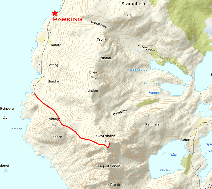
 

Skottinden map


Skottinden, Lofoten Islands, Norway

Photo: Looking towards the steep summit of Skottinden along the north ridge, Lofoten Islands, Norway
 

Skottinden, Lofoten Islands, Norway

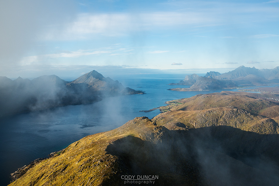
Photo: View north from summit of Skottinden, Lofoten Islands, Norway
 

Skottinden, Lofoten Islands, Norway

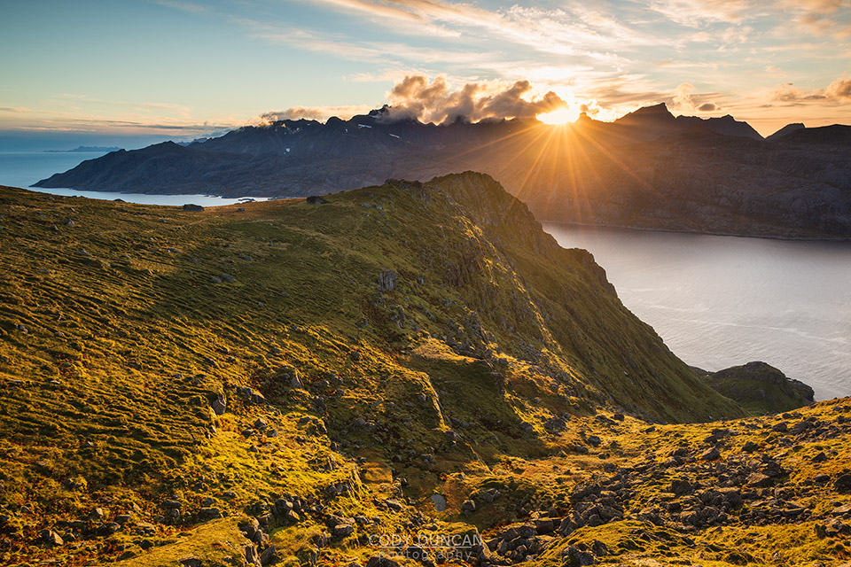
Photo: Last light from the slopes of Skottinden, Lofoten Islands, Norway

0 replies

Leave a Reply

Want to join the discussion?
Feel free to contribute!

Leave a Reply Cancel reply

Your email address will not be published. Required fields are marked *

  • Hiking – Andstabben
  • Hiking – Blåfjellkammen
  • Hiking – Blekktinden
  • Hiking – Branntuva
  • Hiking – Bunes Beach
  • Hiking – Eltofttuva
  • Hiking – Festvågtind
  • Hiking – Flakstadtind
  • Hiking – Fuglhuken
  • Hiking – Håen
  • Hiking – Haugheia
  • Hiking – Helligberget
  • Hiking – Helvetestind
  • Hiking – Hermannsdalstind
  • Hiking – Hestræva
  • Hiking – Himmeltindan
  • Hiking – Holandsmelen
  • Hiking – Hornet
  • Hiking – Horseid Beach
  • Hiking – Hoven
  • Hiking – Hustind
  • Hiking – Justadtinden
  • Hiking – Kleivheia
  • Hiking – Kollfjellet
  • Hiking – Kroktinden
  • Hiking – Kvalvika Beach
  • Hiking – Mahornet
  • Hiking – Mannen
  • Hiking – Markan
  • Hiking – Matmora
  • Hiking – Merraflestinden
  • Hiking – Moltind
  • Hiking – Munken
  • Hiking – Nesheia
  • Hiking – Nonstind
  • Hiking – Nonstind-Ballstadheia
  • Hiking – Nordlandsnupen
  • Hiking – Nubben
  • Hiking – Offersoykammen
  • Hiking – Osthimmeltind
  • Hiking – Reinebringen
  • Hiking – Ryten
  • Hiking – Røren
  • Hiking – Skottinden
  • Hiking – Steinstinden
  • Hiking – Storknubben
  • Hiking – Stornappstinden
  • Hiking – Tindstind
  • Hiking – Veggen
  • Hiking – Volandstind
Search Search
West Lofoten Hikes V4
Northern Light - Lofoten Islands

Recent Posts

  • Friday Photo #711 – Sun’s Farewell
  • Friday Photo #710 – No Eclipse
  • Friday Photo #709 – Summer Fireweed
  • Link to Instagram
  • Link to Youtube
Scroll to top Scroll to top Scroll to top

This site uses cookies. By continuing to browse the site, you are agreeing to our use of cookies.

OKLearn more

Cookie and Privacy Settings


How we use cookies

We may request cookies to be set on your device. We use cookies to let us know when you visit our websites, how you interact with us, to enrich your user experience, and to customize your relationship with our website.

Click on the different category headings to find out more. You can also change some of your preferences. Note that blocking some types of cookies may impact your experience on our websites and the services we are able to offer.

Essential Website Cookies

These cookies are strictly necessary to provide you with services available through our website and to use some of its features.

Because these cookies are strictly necessary to deliver the website, refusing them will have impact how our site functions. You always can block or delete cookies by changing your browser settings and force blocking all cookies on this website. But this will always prompt you to accept/refuse cookies when revisiting our site.

We fully respect if you want to refuse cookies but to avoid asking you again and again kindly allow us to store a cookie for that. You are free to opt out any time or opt in for other cookies to get a better experience. If you refuse cookies we will remove all set cookies in our domain.

We provide you with a list of stored cookies on your computer in our domain so you can check what we stored. Due to security reasons we are not able to show or modify cookies from other domains. You can check these in your browser security settings.

Google Analytics Cookies

These cookies collect information that is used either in aggregate form to help us understand how our website is being used or how effective our marketing campaigns are, or to help us customize our website and application for you in order to enhance your experience.

If you do not want that we track your visit to our site you can disable tracking in your browser here:

Other external services

We also use different external services like Google Webfonts, Google Maps, and external Video providers. Since these providers may collect personal data like your IP address we allow you to block them here. Please be aware that this might heavily reduce the functionality and appearance of our site. Changes will take effect once you reload the page.

Google Webfont Settings:

Google Map Settings:

Google reCaptcha Settings:

Vimeo and Youtube video embeds:

Other cookies

The following cookies are also needed - You can choose if you want to allow them:

Accept settingsHide notification only